
REPORT modules

RCR/SNOWTAM

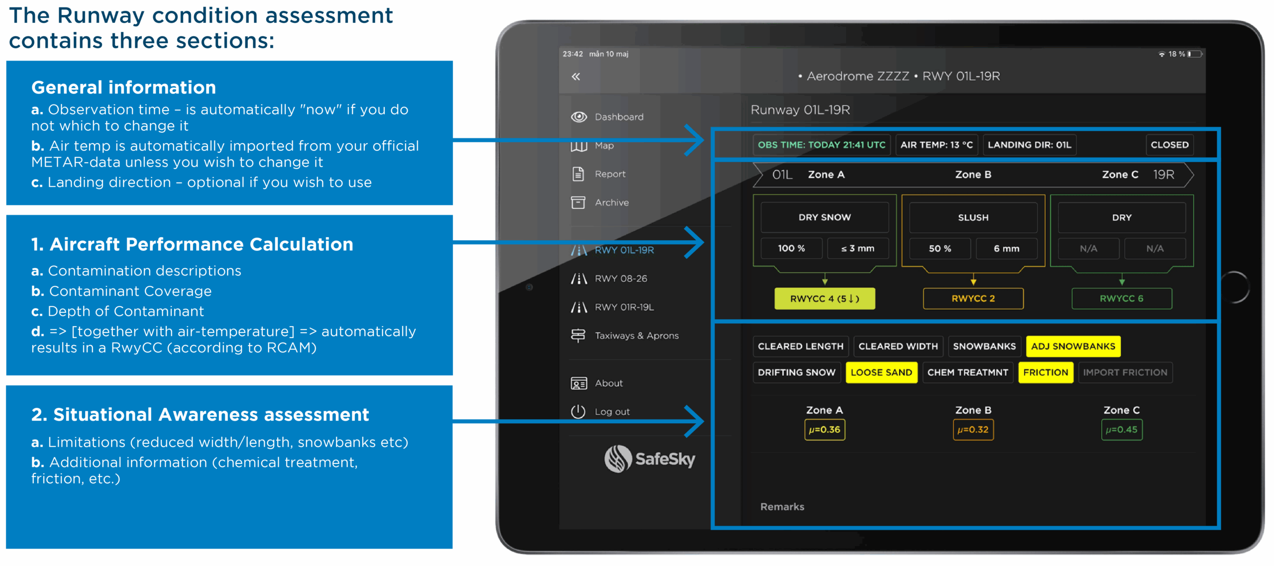
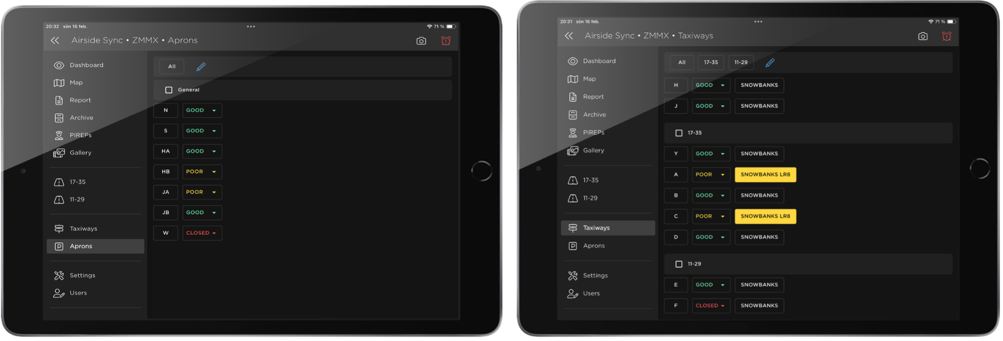
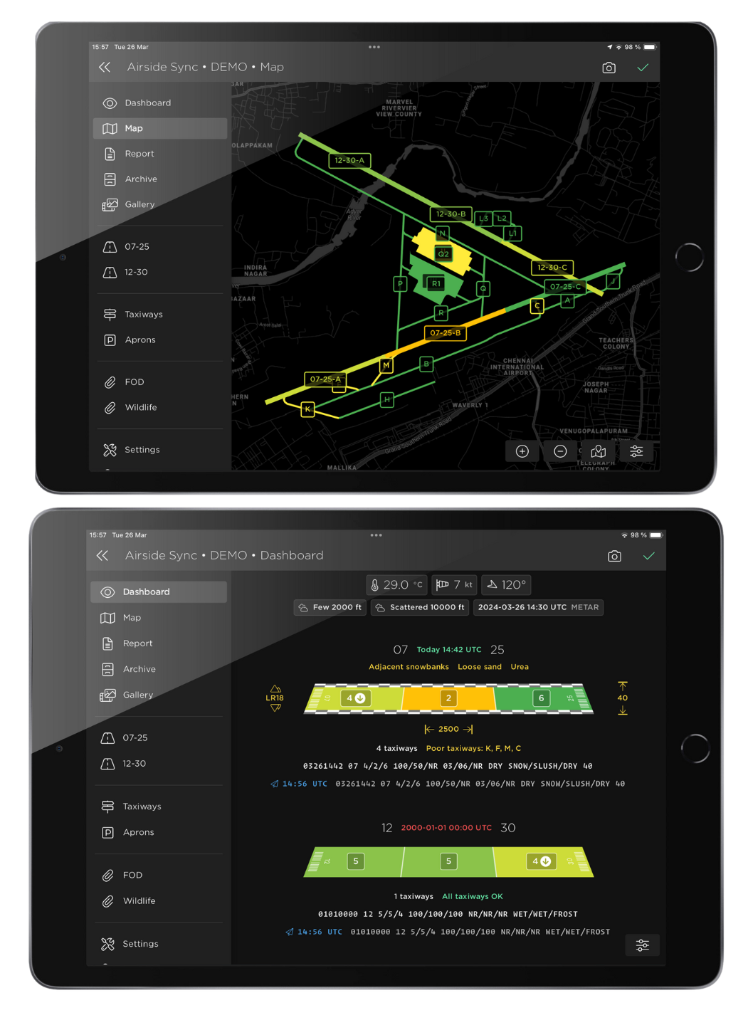
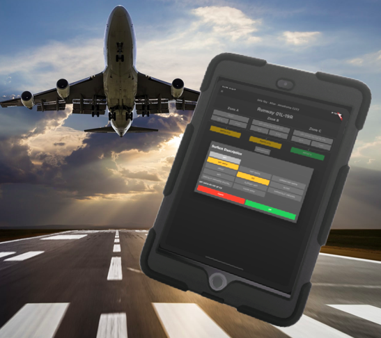
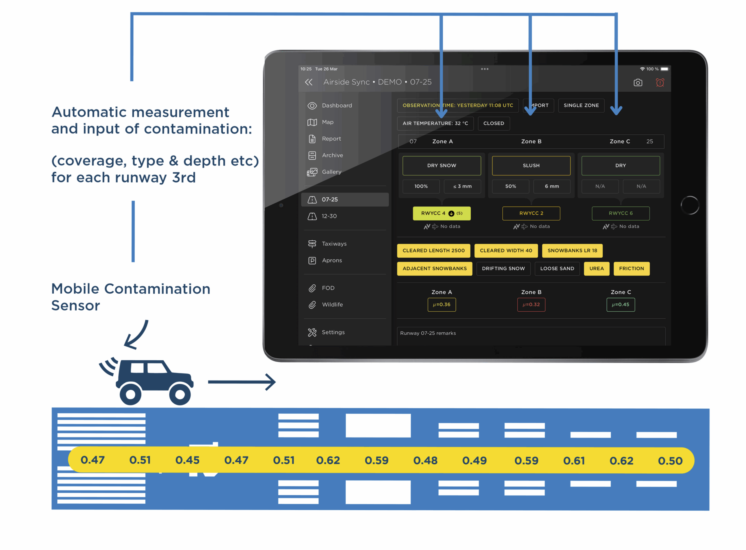
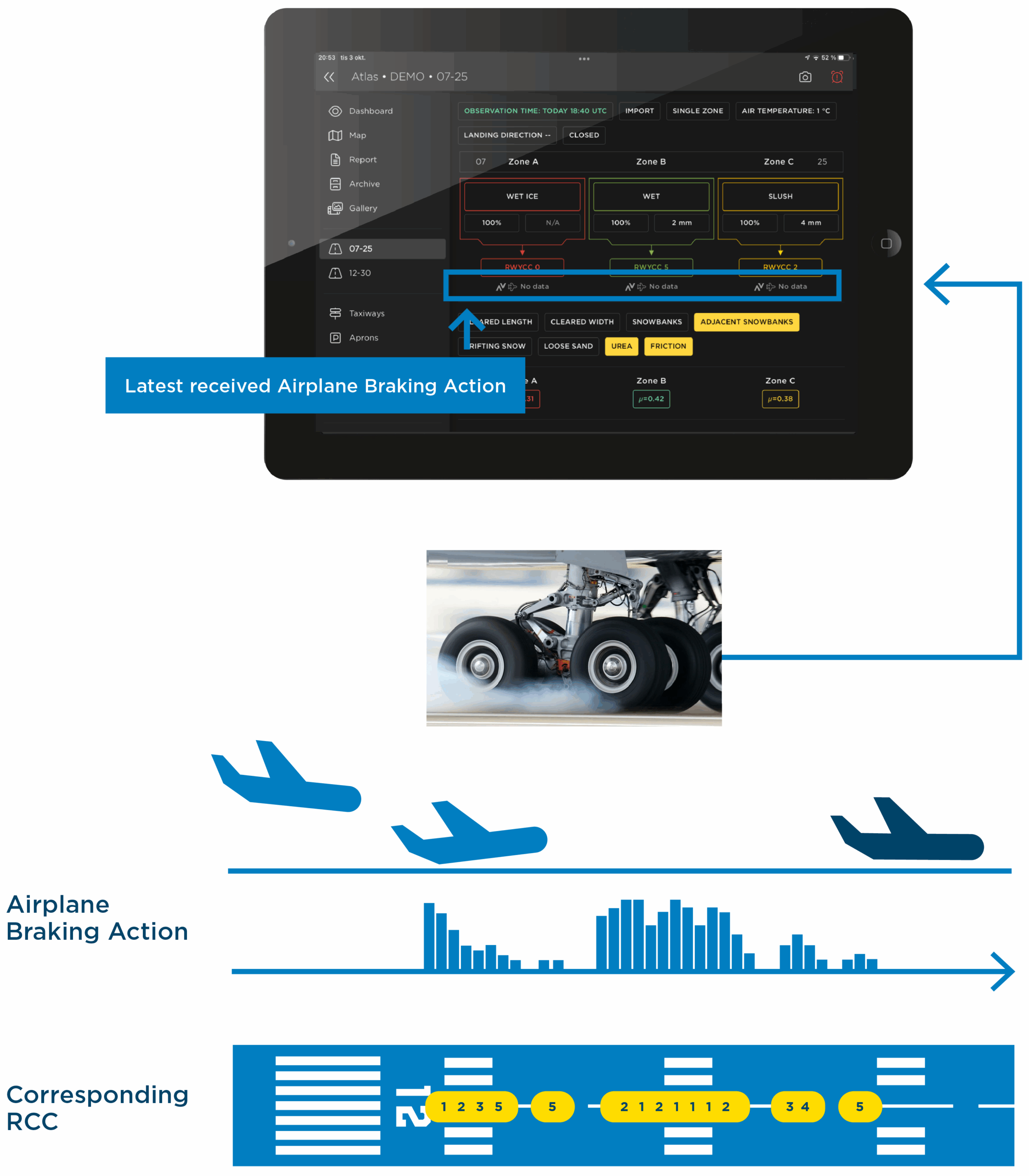
In the fast-paced world of airport operations, real-time information is crucial. Runway condition assessments are not just regulatory—they’re essential to safety and efficiency. Safe Sky’s RCR/SNOWTAM platform redefines how airports manage assessments, delivering a seamless digital solution compliant with ICAO’s Global Reporting Format (GRF). Its intuitive design simplifies reporting and enables real-time sharing of critical information, improving decision-making and streamlining operations.

  • Real-time RCR and SNOWTAM reporting
  • Instant sync with all stakeholders
  • Automated guidance for compliance/accuracy

Introducing RCR/SNOWTAM

Assessment of Runways

Assessing runway conditions with Airside Sync is simple and efficient. The platform automatically imports the latest METAR values, with options to add AWOS data or manual entries. Built-in regulatory guidance ensures compliance throughout, while suggested timestamps and pre-filled standard remarks streamline reporting.

Aircraft performance details—such as contaminant type, coverage, and depth—are used to automatically generate the RwyCC for each runway third. Additional elements like snowbanks, cleared areas, chemical treatments, and friction values can be included as needed for enhanced situational awareness. Read More


Assessment of Taxiways and Aprons

Airside Sync makes it easy to assess taxiways and aprons. Simply select the area and choose its status—Good, Poor, or Closed. You can also indicate snowbank presence and specify their locations. For greater efficiency, multiple taxiways or aprons can be selected and assessed simultaneously with a single update.

To streamline the process further, users can create custom groupings of taxiways for one-click assessments of predefined areas. This flexibility accelerates reporting while ensuring consistency and clarity across all assessments.
Read More

airside sync’s RCR/SNOWTAM module

Visualization

Safe Sky’s platform provides powerful visualization tools that turn raw data into clear, interactive displays. With MapView and Dashboard, users can monitor real-time conditions through intuitive, color-coded maps, offering a complete overview of runways, taxiways, and aprons. These interactive maps show live updates of assessed areas, making it easy to identify contamination, cleared zones, and operational constraints at a glance.

The Dashboard complements this with detailed, structured information such as RwyCC values, METAR data, and situational elements. This clear data presentation helps teams quickly understand the status of all operational areas—supporting faster decisions and more efficient coordination.
Read More

RCR/SNOWTAM REPORT MODULE

Key Features

Efficient Digital Assessments and Reporting

Airside Sync offers the easiest, most user-friendly way to efficiently assess, report, and share Runway Condition Reports—eliminating paperwork and ensuring accurate, ICAO-compliant data every time.

Simultaneous Users

Airside Sync’s digital platform enables unlimited users to collaborate in real time on the same report—streamlining assessments and improving reporting efficiency.

Decision Support System (DSS)

Safe Sky’s built-in Decision Support System guides users through every step of the assessment process, including RwyCC determination. Fully integrated with regulatory requirements, it ensures compliance, reduces errors, and simplifies training for new or seasonal staff.

Start From Scratch or Amend the Previous Condition

Safe Sky lets you initiate reports either from scratch or by updating previous RCR or SNOWTAM reports with new conditions. This time-saving flexibility encourages more frequent assessments, resulting in enhanced safety, compliance, and continuously up-to-date situational awareness.

Real-Time Information Sharing

Airside Sync instantly synchronizes updates across all connected devices, ensuring everyone has real-time visibility. You also have the possibility to generate secure, time-limited links that can be sent to stakeholders for live viewing—no account setup needed.

MapView and Dashboard Visualization

Airside Sync instantly synchronizes updates across all connected devices, ensuring everyone has real-time visibility. You can also generate secure, time-limited links to share with stakeholders for live viewing—no account setup needed.

Non-Winter Mode

Adapting to diverse weather conditions, Non-Winter Mode streamlines the interface by hiding winter-specific fields and displaying only relevant summer data. This makes reporting faster and more efficient, allowing seamless use of the platform year-round.

ATIS Generation

In Airside Sync, reports can be automatically generated and submitted in ATIS format, including both D-ATIS (text) and V-ATIS (audio).

Black Female Air Traffic Controller Holding Tablet in Airport Tower. Office Room is Full of Desktop Computer Displays with Navigation Screens, Airplane Departure and Arrival Data for the Team.

Various User Roles and Account Credentials

Airside Sync lets you assign tailored user roles—Reporter, Sender, Viewer, or Admin—ensuring each user has the right access and permissions for their tasks, streamlining workflows while maintaining security.

Road to airport

Digital Archive and 100% Traceability

All past reports and their metadata are securely stored and accessible from anywhere to users with the appropriate credential levels. This ensures full traceability, simplifies audits, and supports thorough analysis for compliance and continuous improvement.

A busy airport in the rain

Dedicated Training Mode

Besides the reporting environment, Airside Sync also offers a fully replicated training environment that mirrors live operations. This allows staff to practice assessments, learn procedures, and build confidence without affecting real-world data or workflows.

Sensor-Supported RCR / Semi-Automated Reporting

Airside Sync offers a unique integration with mobile contamination sensors, enabling airports to include highly accurate, semi-automated runway assessments. This custom-built feature lets airports seamlessly incorporate sensor technology into the RCR process. The sensors perform up to 40 measurements per second, capturing contamination type and depth across the entire runway—resulting in approximately 4,000 geo-tagged measurements per runway, each assigned to the correct runway third. Airside Sync then uses this data to automatically calculate coverage and support RCR assessments with unmatched precision.

Benefits of Sensor Supported RCR

  • Objective Measurements

    Sensor-based data supplements visual inspections with high accuracy.

  • Faster Reporting

    Real-time data collection accelerates assessments.

  • Reduced Workload

    Staff focus on verification rather than manual measurement.

Read More

Airplane Braking Action Data Integration

Integrating airplane braking action data adds an extra layer of accuracy and safety to RCR assessments. Airside Sync enables seamless incorporation of real-time aircraft feedback into the assessment platform, providing objective insights into runway friction and performance. By correlating braking data with reported conditions, Safe Sky’s platform improves the precision and reliability of RCR assessments.
Read More

Ground crew preparing airplane before flight

PIREPs in Airside Sync

Airside Sync offers an additional module for seamlessly managing and utilizing Pilot Reports (PIREPs) directly within the platform. Users can import data from existing systems or enter it manually in the PIREP module. This integration enhances decision support during runway assessments and triggers alerts if discrepancies arise between reported conditions and PIREP data, as outlined in GRF regulations.

PIREPs also serve as a valuable follow-up tool, allowing airports to analyze and compare actual braking performance against reported RwyCC—improving accuracy and safety in future assessments.
Read More

Information Sharing in Real-Time

Safe Sky’s platform enables real-time synchronization across all connected users. When a condition is reported or updated, it instantly appears on every device—keeping everyone from air traffic control to ground teams in sync.

Additionally, Airside Sync’s Temporary Viewer Link lets users generate secure, time-limited URLs for external stakeholders to view current conditions without account setup. This enables fast, effortless sharing with partners, emergency teams, or regulators—supporting quick, coordinated responses to changing airside conditions.

Benefits of Visualization and Real-Time Sharing

Improved situational awareness

Clear, up-to-the-minute information allows for faster, more informed decisions.

Streamlined Communication

All users see the same data simultaneously, reducing miscommunication.

Faster Response Times

Real-time updates allow for quick adjustments and faster maintenance response.

Benefits

Safe Sky’s RCR/SNOWTAM platform offers a wide range of benefits that enhance both safety and operational efficiency:

Operational Efficiency and Time Savings

The RCR/SNOWTAM module significantly reduces the time and effort required to assess and report runway conditions. With real-time collaboration, instant updates, and automatic generation of SNOWTAM and ATIS reports, airports can enhance operational efficiency and focus more on safety-critical tasks—resulting in more frequent assessments and reports.

Enhanced Safety and Compliance

By automating key aspects of the reporting process, Safe Sky ensures full compliance with ICAO’s GRF and regulatory requirements. The platform’s built-in decision support minimizes the risk of incorrect data entry, contributing to safer airside operations.

Improved Situational Awareness

With real-time updates and detailed visualizations on the map and dashboard, airport personnel have a clear view of current conditions at all times. This improved situational awareness enables faster response and more informed decision-making.

Streamlined Data Management and Analysis

Safe Sky’s digital platform consolidates all reports into a single archive, making it easy to retrieve past assessments for analysis. This helps ensure consistency across reports and enables deeper insights into historical data—supporting data-driven decisions and continuous operational improvement.

Seamless Communication and Collaboration

Real-time data synchronization across devices keeps all stakeholders on the same page, with up-to-date information available at a glance. Whether in the ops office, control tower, or on the ground, everyone has instant access to the same data—improving communication and coordination.

Predictive and Historical Analysis

By providing access to historical and real-time data, Safe Sky helps operators identify trends, track runway changes, and make proactive, data-driven improvements.

Good, great or all-inclusive?

Which one suits you best?

Airside Sync BASIC

Safe Sky Airside Sync with the astonishing User Experience, Functionalities, Decision Support etc that is the trademark of Safe Sky Airside Sync, packaged to provide a very reasonable price. An amazing digital tool to support condition assessment and SNOWTAM-reporting at an affordable cost.

Airside Sync Atlas PREMIUM

The full, standard versiion of Safe Sky Airside Sync with all possible features and modules available; MapView, RCR, Archive, Desktop Version, Open API, etc

Airside Sync PREMIUM PLUS

Safe Sky’s full-blown product with all available features and modules opt in, including SLA Gold.

Features Basic Premium Premium Plus
No of users included 5
additional user
100€/user
Unlimited Unlimited
Dashboard view Included Included Included
Report view Included Included Included
Map view Unavailable Included Included
Send report: email Included Included Included
Send report:SMS Unavailable Add-on Included
Send report: AFTN Unavailable Add-on Included
Send report: AIXM via AMQP (SWIM) Unavailable Add-on Included
Decision support Included Included Included
Non-winter mode Included Included Included
Two Factor Authentification (optional) Included Included Included
Archive + Meta Data Archive (100% tracability) Add-on Included Included
Desktop UI + Anonymous viewers (web) Add-on Included Included
Customizable Stock Phrase functionality Add-on Included Included
Delcing type registration Unavailable Included Included
Friction reporting Unavailable Included Included
API access Unavailable Included Included
Send RCR (not SNOWTAM) Unavailable Included Included
SSO (Single Sign On) Unavailable Add-on Included
SMS-functionality (notifications, alerts etc) Unavailable Add-on Included
Send ATIS report (incl Voice-ATIS) Unavailable Add-on Included
Photos / gallery view Unavailable Add-on Included
Sensor integration Unavailable Add-on Included
NavBlue RunwaySense* Unavailable Add-on Included
*integration and Airside Sync functionality – fee does NOT include cost for RunwaySense      
Additional reporting and supporting modules
PIREP Unavailable Add-on Included
Analytics Unavailable Add-on Included
Custom Forms incl templates (FOD, WLM, etc) Add-on Add-on Included
FOD* Add-on Add-on Add-on
WLM* Add-on Add-on Add-on
Airside Inspection Add-on Add-on Add-on
Task Management* Add-on Add-on Add-on
Supporting Features
Media Capture – add photos or videos to reports Unavailable Add-on Included
(included in the modules * above)      
SLA      
Bronze support Included Included Included
Silver support Add-on Included Included
Gold support Unavailable Add-on Included
Platinum support Unavailable Add-on Add-on

Included Included

Add-on Available as add-on

Unavailable Unavailable

Ready For More Accurate and Efficient Assessments of Runway Conditions?

Want to know more on how to get simpler and more efficient assessments of runway conditions? Drop us a line–or give us a bell. Click the button below, to get in touch!

Contact us!